Thursday, February 17, 2005


A small waterfall where we had a tea break.

A tight squeeze in the cave. And a pretty good shot of them spectacles.

This is the new fashion outfit for the spring season. Liam, one of our guides applied the nosepiece tape for "extra protection". The hole in the back is where we started our rappel. I like the Skywalker boots. They were suprisingly grippy on the wet rock.

Rappelling 100-meters into the Lost World at Waitomo. I had to break out the gasmask inserts from Baghdad, because, "I knew things were going to get a little hairy."

Waiheke Island

I ended up going to a Maori Village while in Rotorua to attend a show and to enjoy a nice hangi. A hangi is the way the Maori used to cook feasts. This involved heating up rocks in a fire, throwing it in a deep hole with some food, and covering the hole with wet leaves to let the steam cook the food. The dance and show was pretty awesome. They showed us a haka, which is their war dance, and all their different weapons and tactics. The food was pretty good as well. We had some chicken, lamb, potato, and kumara, a type of sweet potato. I stuffed myself.
The next day I headed to Waitomo Caves, an area with a lot of limestone sinkholes. I signed up for the Ultimate Lost World tour with Waitomo Adventures. This was a seven-hour trip with a 100 m rappel into a huge hole. It was great. We then hiked upstream through an underground cave and river. We wore helmets, headlamps, and thick wetsuits. The water was pretty cold, but the wetsuits were thick. We ended up crawling, climbing, swimming, and jumping off of waterfalls, all underground. When we turned off our headlamps, all we could see were glowworms, small pinpoint maggots on the walls. It was a blast. Hours later, we came out of a cave, two kilometers from our starting point. We finished the day with a nice barbecue.
The next day I took a four hour bus trip to Auckland, and then walked to the wharf to take a ferry to Waiheke Island. Waiheke Island is a large island in the Hauraki Gulf. The ferry ride is about 35 minutes long and takes you so far away from the city. I had planned on being here for three nights, but I've decided to spend six nights here. There are many coves and hidden beaches here, most of them are next to million dollar estates, summer homes for the elite of Auckland. There is wonderfully, not much to do here, so I have been relaxing and preparing for the next phase of my trip. In a couple days I will head to Auckland, and then after that...you'll see.

Oneroa Beach on Waiheke Island. Twenty miles, or a 35-minute ferry ride from downtown Auckland. It is a world away from the city. Quiet and peaceful.

Craters of the Moon, a geothermic place with steam vents and bubbling mudpools.

Huka Falls. Not really that high, but pretty turbulent.

View of the Emerald Lakes, Blue Lake, and Lake Taupo off in the distance from Red Crater on the Tongariro Crossing. The mist is actually from thermal vents and cracks just off the trail.

There is a trail of people hiking to the top of the Mangetepopo Saddle to the left of Mt. Ngauruhoe. The scree sloped I hiked up was along that rocky ridge below the red band to the left of the peak of Mt. Ngauruhoe.

Mt. Ngauruhoe, aka Mt. Doom.

Mt. Ruapehu. I hiked to the crater rim on a foggy day.

Sunday, February 13, 2005

Tongariro and Taupo

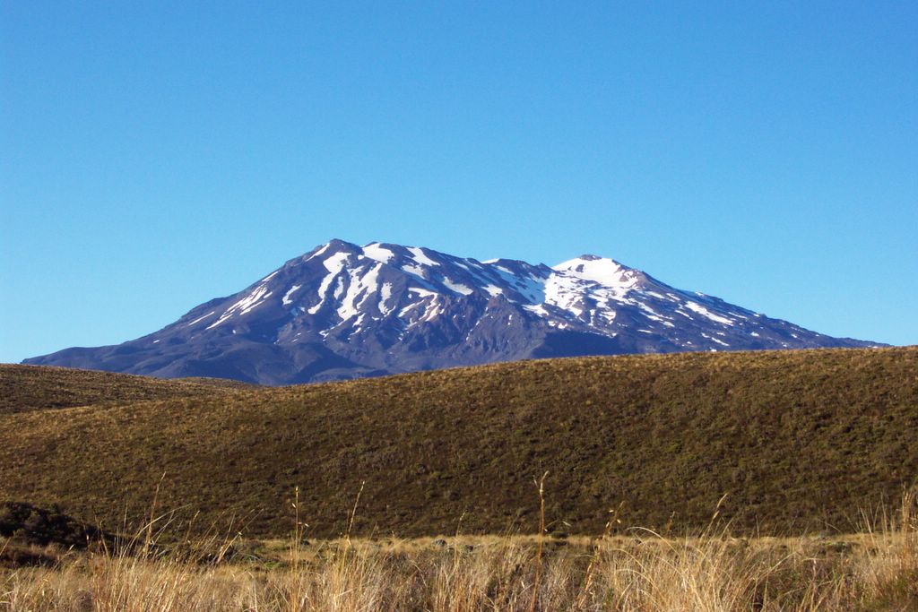
I went to National Park Village after Wellington. I was there to do the Tongariro Crossing. It's a 17 km hike between Mt. Tongariro and Mt. Ngauruhoe. This is supposed to be the best one-day hike in the North Island, but it's often shrouded in clouds. When I got there it was raining, and the weather forecast predicted clouds for the next day, so I hitchhiked to the Mt. Ruapehu ski lifts about 15 km from National Park Village. They filmed some more the LOTR movies there, but I couldn't tell you where or what. Mt. Ruapehu, like all the other mountains in the region, are volcanos. Mt. Ruapehu last erupted in 1996. It doesn't have a proper peak, but it does have a huge crater, so I hiked up through the ski resort to the crater rim, where I found myself in a near-total white out. Visibility was about 20 meters, so I decided to find my way back down in the mist.
The next day I went and hiked the Tongariro Crossing. It was pretty crowded on the track. I made a side trip to hike to the top of Mt. Ngauruhoe, which was used as Mt. Doom. The clouds came in halfway up the peak, so I didn't get much of a view, but I had a blast sliding down the scree slope to the bottom. The Tongariro Crossing track was amazing passing though a couple craters and steaming volcanic vents.
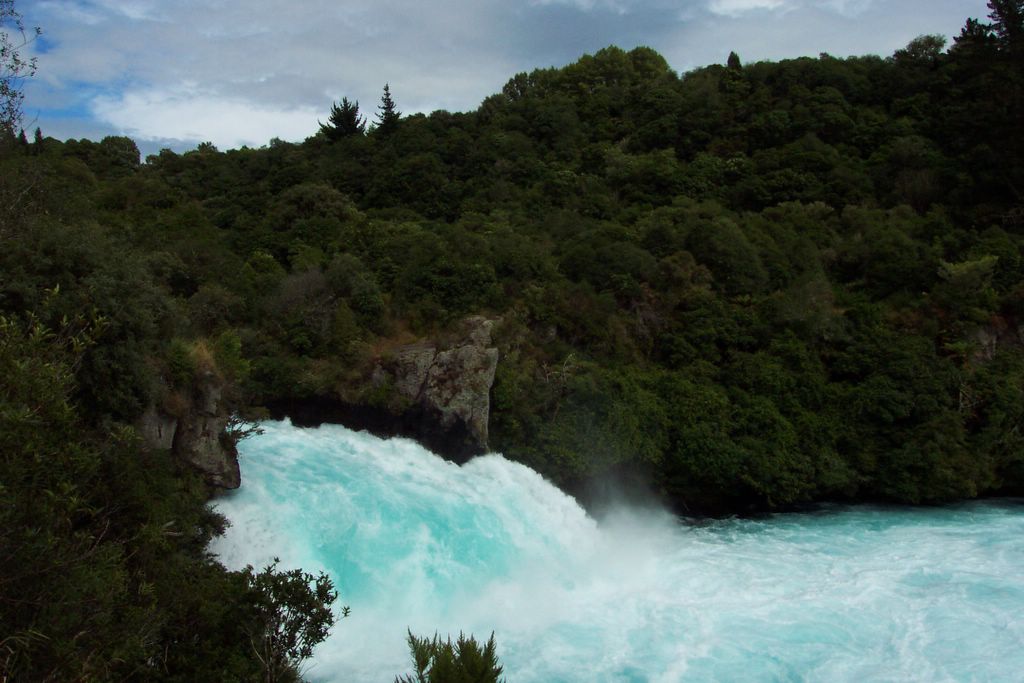
The next day I went to Taupo, a city on the northern edge of Lake Taupo, the largest lake in New Zealand. It is stocked with California Rainbow Trout. These monsters are huge compared to the ones in California. I am not sure why. They get up to 20 lbs, I am told. They look like salmon. I didn't do any fishing, but I hiked to a place called Craters of the Moon, which was another geothermic area where I could see (and smell) steaming vents and bubbling mudpools. I also walked to Huka Falls, which is on the Waikato River, which empties out of Lake Taupo. The Falls were very impressive, if not exactly high. The river narrowed from 100 m across to 10 m across, making a very turbulent channel. I also got to bathe in the natural spa that emptied into the pristine waters of the river. That was pretty cool.
I came to Rotorua last night. This is known as Sulfur City because it's sitting in a huge crater and there are geothermic hot springs everywhere. Everywhere? yeah, like in people's yards and stuff. It's funny because if you have a hot spring on your property, you just throw some rocks on it so you know not to walk over the vent and burn yourself. It also stinks like rotten eggs here, but it's not as bad as it sounds. Well, maybe it is.
I am not sure where I will be going next, but chances are I'll be headed to the Waitomo Caves to do some caving.