Saturday, January 29, 2005


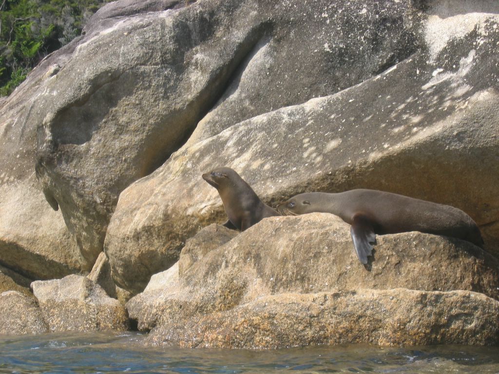
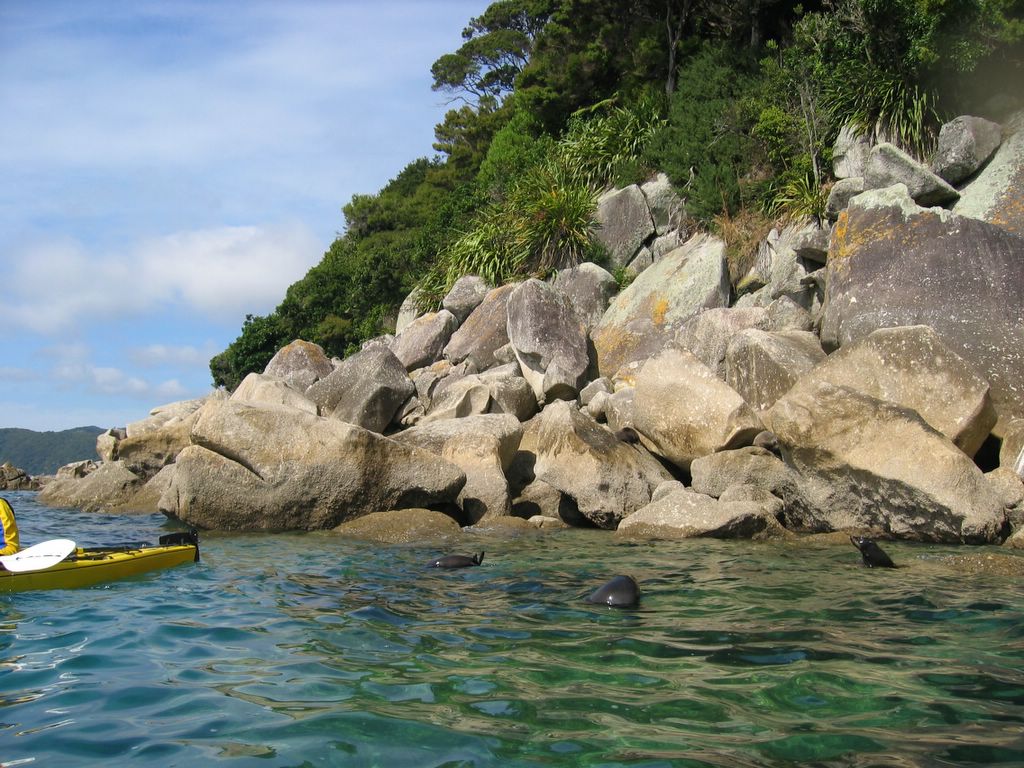
Just another beach at Abel Tasman.

Cleopatra Pools, where you can take a freezing swim to wash off the sweat. Or not.

Torrent Bay as it is filling up. I had hiked across from the right side to the left a couple hours prior to this photo.

Torrent Bay. When it empties out at low tide, you save about 70 minutes of hiking by cutting across the mudflats. The mudflats are littered with empty clam shells from the sandpipers. The low tide leaves the boats all high and dry.

Anchorage Bay at Abel Tasman, where we slept on a houseboat overnight. The biggest boat in the bay is the houseboat.

Seals sunning themselves on the rocks. I forgot to pack my bat. Just kidding...

Three seals saw us and slipped into the water to check us out. They proceeded to scratch their butts at us.

Kayaking in the Tonga Marine Reserve at Abel Tasman National Park. That's a seal doing the backstroke next to us in the water.

Abel Tasman National Park

I'm back in Nelson again, but I spent the past couple nights at Abel Tasman National Park. This is one of the most popular backpacking trails in New Zealand. It's a three to four day hike on the coast with some awesome views of jungle and beach. I signed up for a catered kayak trip to a marine reserve and got to swim around in the freezing water. We had some close encounters with seals that slipped into the water to check us out. It was pretty amazing to be a few feet from them. It was a pretty small group of us (four tandem kayaks). The conditions were perfect. It was really glassy in the morning, and in the afternoon the wind picked up, so we formed a flotilla and put up a sail and held on tightly and sailed into our cove. We had a couple races and our boat won. It didn't hurt that my navigator (steering with pedals) was actually a Canadian from Newfoundland with a season of sea-kayak guiding under her belt.
I got to stay on a houseboat with some guests. It was so different from the Whitsundays, in Australia. We had a nice BBQ and then settled in with warm drinks on the deck talking to Danes, Swiss Germans, Dutch, and a Canadian. It was nice and cool at night so we bundled up below decks under the comforters.
Today I hiked to a couple sights and then on my way out of the park.
Tomorrow I head to Picton and hopefully spend a few nights on the Queen Charlotte Track.

Tuesday, January 25, 2005

View from Mt. Beasley

View from Mt. Beasley

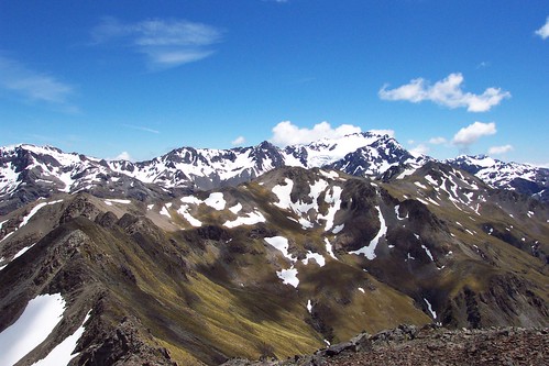
Once again Mt. Rollerston in the background and Avalanche Peak to the right of Mt. Rollerston. The traverse continues down the left ridge from Avalanche Peak to Lyell Peak which is near the center of the photo, and then along the ridge all the way to the left of the photo, then zig-zagging along that knife blade ridge toward me. This has been the best hike I've done so far. The views and the exposure and route-finding made it incredibly exciting.

View of Mt. Rollerston from Avalanche Peak

View of Mt. Rollerston from Avalanche Peak

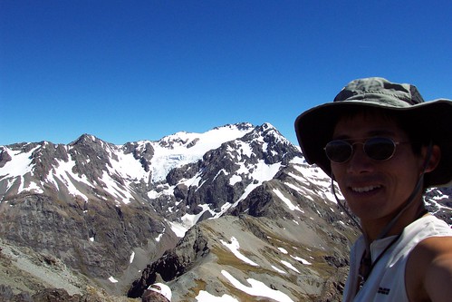
This is supposed to be the best day hike in all of New Zealand according to the Lonely Planet. They have a race called the Avalanche Peak Challenge here every year. The winner usually makes it up in 55 minutes; it took me 90. Oh well. The hike is pretty good, but I ended up doing a traverse along the ridge over to Lyell Peak and Mt. Beasley. It was pretty exposed on this knife ridge, but fortunately there was hardly any wind. And of course, no one on this traverse.

Atop Mt. Aiken (1863 m)

Atop Mt. Aiken (1863 m)

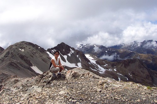
I blazed up this peak from Arthur's Pass. Once again, there was no one else on this trail. From the top, I had a 360 view all around wiith no evidence of human encroachment except for a few buildings in the valley of Arthur's Pass.

Warm in Nelson

After three nights in Arthur's Pass (760 m elevation), I've taken the seven hour trip up to Nelson, which is at the northern coast of the South Island. Arthur's Pass was pretty cold the first night, but there was a toasty coal stove heating the lounge. It's a small village there with one store/gas station and a couple hotels and a couple hostels. I got to do a couple stiff day hikes there, visiting both sides of the valley. The first hike was to Mt. Aiken at 1863 m, then the next day I hit Avalanche Peak (1833 m), Lyell Peak (1828 m), and Mt. Beasley (1836 m). Now my Achille's tendons are paying the price. I was totally inspired by three guys I met the first night. It was cold and rainy, but they had just done a training trail run (25 km up to 1050 m) in preparation for the Coast to Coast challenge, a one-day 255 km race in a few weeks. It's one of those multisport races with trail running, river kayaking (class 2), and road-biking. These guys set off to kayak for five hours the next morning.
Now I'm in Nelson to head to the Abel Tasman National Park, but I still have to figure out what I plan on doing there.

Fern trees in the rainforests next to the glaciers. The silver fern, by the way, is the national symbol for New Zealand. I'm not sure if I've encountered an silver fern during my hikes. I did encounter trees like these in Australia in the Daintree National Park. They tell the tourists that these mighty trees grow about one to three centimeters a year. I don't know if this is true or not, but you can tell the age of the tree by its height. There were signposts showing where the glaciers had receded from 1950 and even 1750. You could tell that the trees in those areas were clearly of limited height, so maybe it's not a bunch of crap they tell the tourists.

Franz Josef Glacier

Franz Josef Glacier

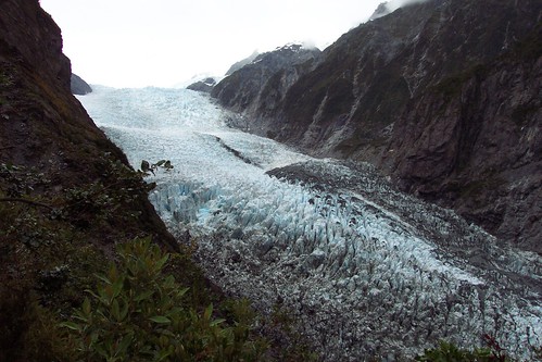
I hiked up to Robert's Point above Franz Josef. This glacier is actually creeping forward about 1 meter a day. This is right next to a rainforest. There are a million helicopters buzzing around above taking tourist up for a view of the mountains and taking them on jaunts along the glacier.


More sheep we encountered on the bus. Sometimes traffic comes to a complete halt because of grazing animals crossing the roads. I did not encounter a single multi-laned highway in the South Island.

Mt. Aeolus

Mt. Aeolus

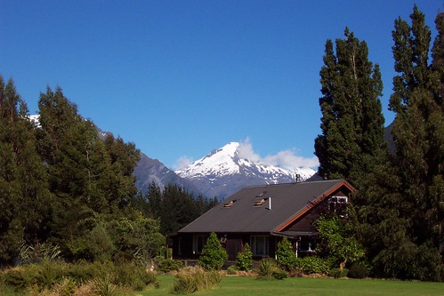
This was just a 15 minute stop on my bus ride from Queenstown to Fox Glacier, but it was so pretty I had to take a picture.


A rainy day in the Milford Sound. It's supposed to be pretty impressive with the big waterfall. It's a fiord. Whatever.

View from Ben Lomond Peak

View from Ben Lomond Peak

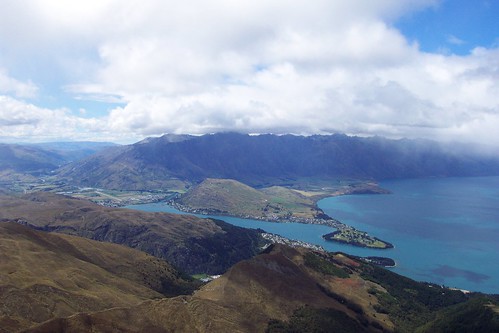
This is a peak right behind Queenstown. This view overlooks the town of Queenstown below and the Frankton Arm which is that thin slice of Lake Wakatipu that extends to the right. This lake is huge, by the way. It was hailing and very windy up here. I was wearing shorts. The trail I took comes along the ridge that you see above Queentown, which is the town on the bottom part of the lake. This ridge goes to the bottom left side of the photo. It was really windy and exposed but easily navigable.


Queenstown and the Remarkables

Queentown and the Remarkables

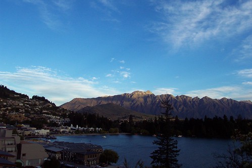
This is the view from my hostel. This place was so nice that I ended up staying four nights. Amazingly this town is now well known for its high-adventure pursuits rather than it's beauty. They filmed a lot of the Two Towers in the surrounding area. The Remarkables are the peaks lit up by the setting sun. This is Lake Wakatipu, a huge lake in the South Island.

Up at Sealy Tarn

Up at Sealy Tarn

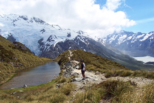
This is on the hike to the Mueller Hut. For trampers (backpackers) in NZ, you don't necessarily need a tent as they have limited spaces available in alpine huts. A tarn is a mountain lake. That's Mt. Sefton behind me and Mt. Cook to the right. Sefton appears to loom much higher, but Mt. Cook is still several miles away.

Mt. Cook from afar

Mt. Cook from afar

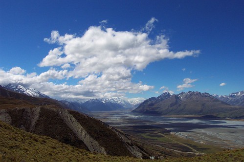
This is a glacial valley that was carved out by the Tasman glacier. It dumps into Lake Pukaki which is a brilliant powder blue because of the "glacial flour"; as a glacier grinds rock into powder, the fine silt goes into the water. I hiked a couple hours to through grazing sheep to get up here. No tourists anywhere.


Pancake rocks at Punikaiki. My school report on the rocks at Punikaiki is as follows:
The Punikaiki Pancake Rocks were formed hundreds of thousands of years ago. Scientists today are still puzzled on exactly how they were formed.